An intelligent platform formodern wildfire operations.
AI-powered tools that connect wildfire inspections, assessments, and field coordination—supporting mitigation, response, and recovery.
Corpus Christi

Stockton
California
Sanibel
Florida

Puerto Rico

Preston County
West Virginia

Pompano Beach
Florida

Pitt County
North Carolina
Pensacola
Florida
Panama City
Florida

Old Orchard Beach
Maine
Okaloosa County
Florida
Monroe
Louisiana

Miramar
Florida
Maine BOI

Lewes
Delaware

Hollywood
Florida
Hattiesburg
Mississippi
Hampton
Virginia
Gila County
Arizona
Fort Myers
Florida
Florissant
Missouri

Fairfax
Virginia
DeSoto County
Florida

Dauphin Island
Alabama
Cottage Grove
Oregon
Chatham County
Georgia

Cape Coral
Florida
Ascension Parish
Louisiana
Tangipahoa Parish
Louisiana

Port Arthur
Texas

Lincoln
Nebraska
Leon County
Florida
Lee County
Florida
Monmouth County
New Jersey
Sea Isle City
New Jersey
South Pasadena
Florida
Santa Barbara County
California
FDEM
Florida
Alexandria
Virginia
Terrebone Parish
Louisiana

Concord
California
Norfolk
Virginia

Peterborough
New Hampshire
Escambia County
Florida
Calvert County
Maryland

Wilson County
Tennessee

Key West
Florida
West Palm Beach
Florida

Las Cruces
New Mexico
Naples
Florida

Miami
Florida
Fort Pierce
Florida

Tampa
Florida

Santa Rosa County
Florida

Palm Beach County
Florida

Orting
Washington

Ocean Township
New Jersey
Hoboken
New Jersey

Jefferson Parish
Louisiana

Hialeah
Florida

Harris County
Texas

Georgetown County
South Carolina

Longport
New Jersey

Destin
Florida
Clearwater
Florida

Cape May
New Jersey

Brick
New Jersey

Kitty Hawk
North Carolina

Cedar Rapids
Iowa

Coral Gables
Florida
Corpus Christi
Stockton
California
Sanibel
Florida
Puerto Rico
Preston County
West Virginia
Pompano Beach
Florida
Pitt County
North Carolina
Pensacola
Florida
Panama City
Florida
Old Orchard Beach
Maine
Okaloosa County
Florida
Monroe
Louisiana
Miramar
Florida
Maine BOI
Lewes
Delaware
Hollywood
Florida
Hattiesburg
Mississippi
Hampton
Virginia
Gila County
Arizona
Fort Myers
Florida
Florissant
Missouri
Fairfax
Virginia
DeSoto County
Florida
Dauphin Island
Alabama
Cottage Grove
Oregon
Chatham County
Georgia
Cape Coral
Florida
Ascension Parish
Louisiana
Tangipahoa Parish
Louisiana
Port Arthur
Texas
Lincoln
Nebraska
Leon County
Florida
Lee County
Florida
Monmouth County
New Jersey
Sea Isle City
New Jersey
South Pasadena
Florida
Santa Barbara County
California
FDEM
Florida
Alexandria
Virginia
Terrebone Parish
Louisiana
Concord
California
Norfolk
Virginia
Peterborough
New Hampshire
Escambia County
Florida
Calvert County
Maryland
Wilson County
Tennessee
Key West
Florida
West Palm Beach
Florida
Las Cruces
New Mexico
Naples
Florida
Miami
Florida
Fort Pierce
Florida
Tampa
Florida
Santa Rosa County
Florida
Palm Beach County
Florida
Orting
Washington
Ocean Township
New Jersey
Hoboken
New Jersey
Jefferson Parish
Louisiana
Hialeah
Florida
Harris County
Texas
Georgetown County
South Carolina
Longport
New Jersey
Destin
Florida
Clearwater
Florida
Cape May
New Jersey
Brick
New Jersey
Kitty Hawk
North Carolina
Cedar Rapids
Iowa
Coral Gables
Florida
Coordinated response

starts here.

Enforce defensible space standards with confidence.

Plan and map ahead of wildfire season.

Coordinate evacuations and response.

Support recovery with structured field data.
Tools that support fire
prevention, response, and recovery.
Forerunner unifies defensible space inspections, wildfire hazard data, damage assessments, and public outreach into one shared system — so your team can stay proactive and informed at every stage.
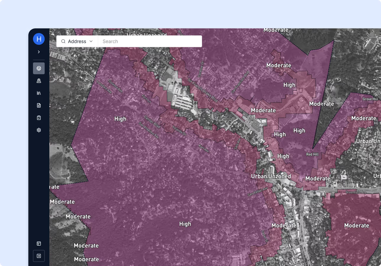
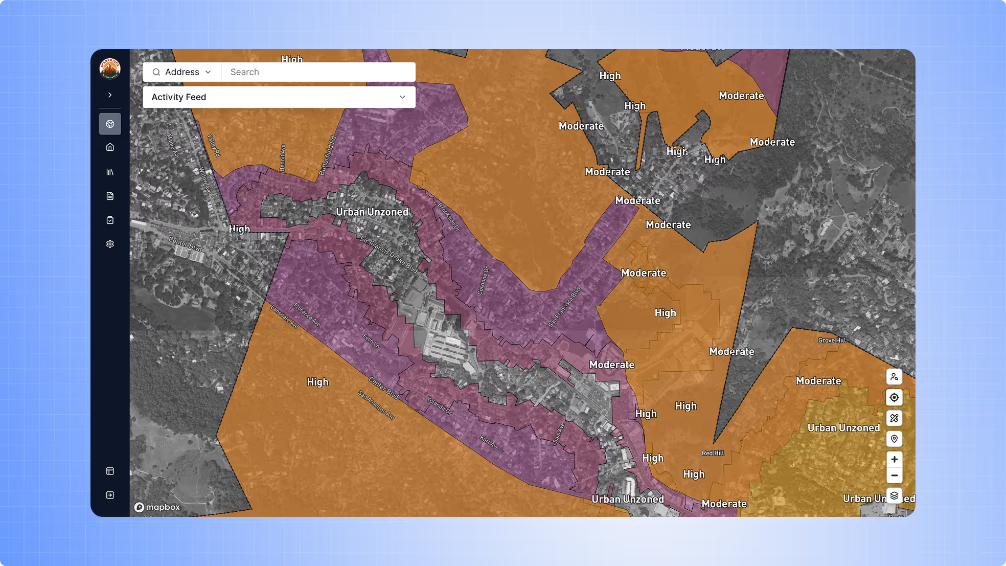
Hazard and asset mapping.
Layer wildfire risk zones, fire history, structures, hydrants, and vegetation data to prioritize mitigation efforts.
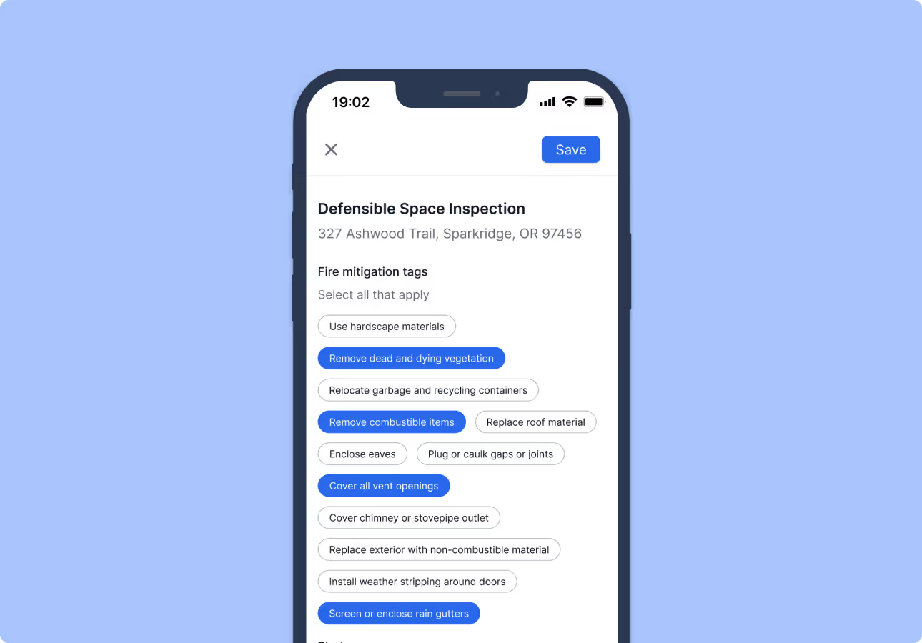
Offline mobile inspections.
Log defensible space inspections in the field, upload photos, and sync when back online.
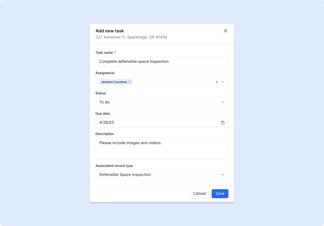
Tasking and coordination tools.
Assign tasks to inspectors or field crews, monitor status, and manage workflows across phases.
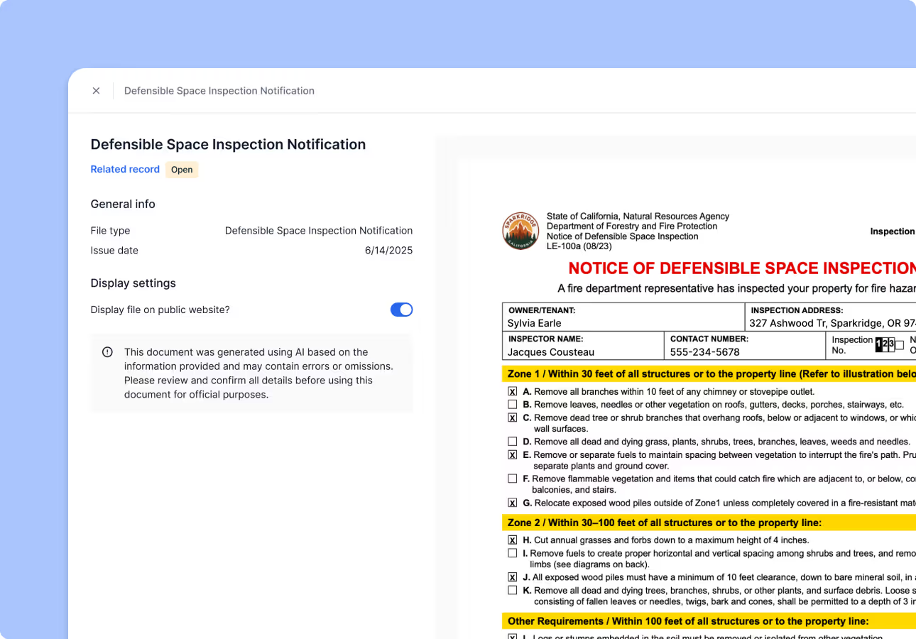
Pre-filled reports and notices.
Generate defensible space violation notices and inspection reports instantly — with no manual formatting. Send reminders, updates, and inspection results directly to property owners to improve compliance.
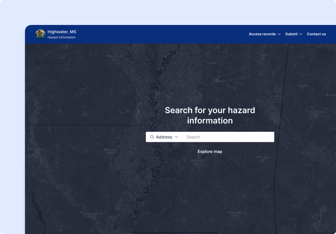
Public-facing property lookup.
Allow residents to search their address to see defensible space requirements, past inspections, and open tasks.
Results from the field.


Communities accelerated response efforts during and after wildfires.

Forerunner saved over 40 hours during a 200-structure inspection process.

Ready to modernize your wildfire workflows?
Book a demo